Analyzing Tourist-Local Interaction in US Cities
🔍 Exploring How Tourists and Locals Share Urban Spaces
Have you ever wondered how tourists and locals interact in bustling cities? Do they visit the same places, or do they stick to their own corners? These questions are more than just curiosities—they’re crucial for urban planning, tourism development, and creating cities that work for everyone. In our recent study, we dove into the spatial patterns of tourists and locals in ten major U.S. cities using Flickr data. What we found reveals fascinating insights into how cities are used and how they might be improved.
🛠️ How We Did It: Mapping the Footprints of Tourists and Locals
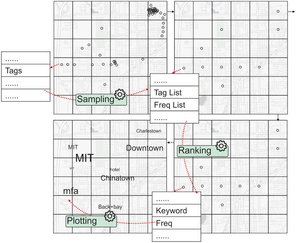
To understand where tourists and locals go, we turned to Flickr, a photo-sharing platform where users often tag their photos with locations. We analyzed over 2.2 million geotagged photos from ten cities: Atlanta, Boston, Chicago, Houston, Los Angeles, New York City, Orlando, San Francisco, Seattle, and Washington, D.C. Using advanced spatial analysis techniques, we identified hotspots for both tourists and locals, measured how mixed or segregated their destinations were, and even explored the reasons behind their visits by analyzing photo tags.
Here’s a quick breakdown of our methods:
- Density-Based Clustering: We grouped photos to identify unique destinations, ensuring we didn’t count the same place multiple times.
- Dissimilarity Index: This helped us measure how much tourists and locals overlapped in their destinations. A low score means they visit similar areas, while a high score indicates segregation.
- Tag Clouds: By analyzing the most common tags in each area, we uncovered what made certain places attractive to tourists or locals.
📊 What We Found: Tourists and Locals Don’t Always Mix
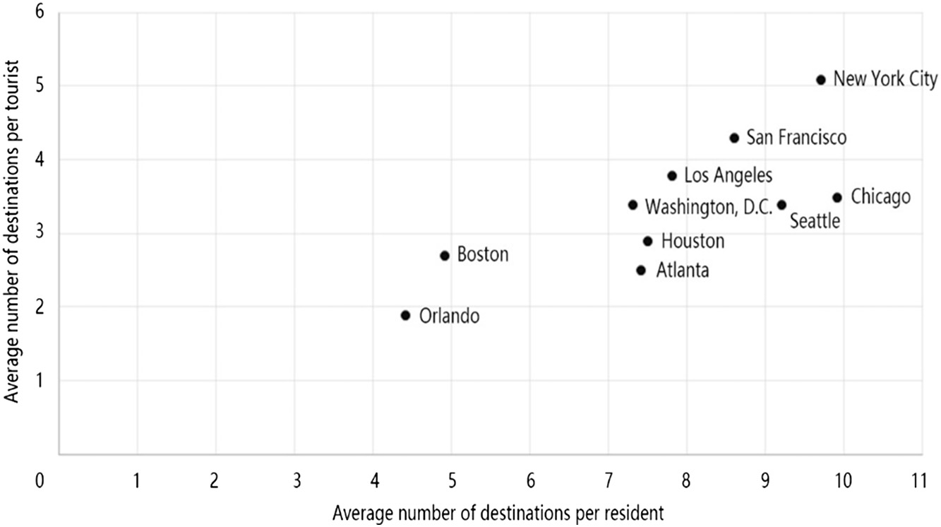
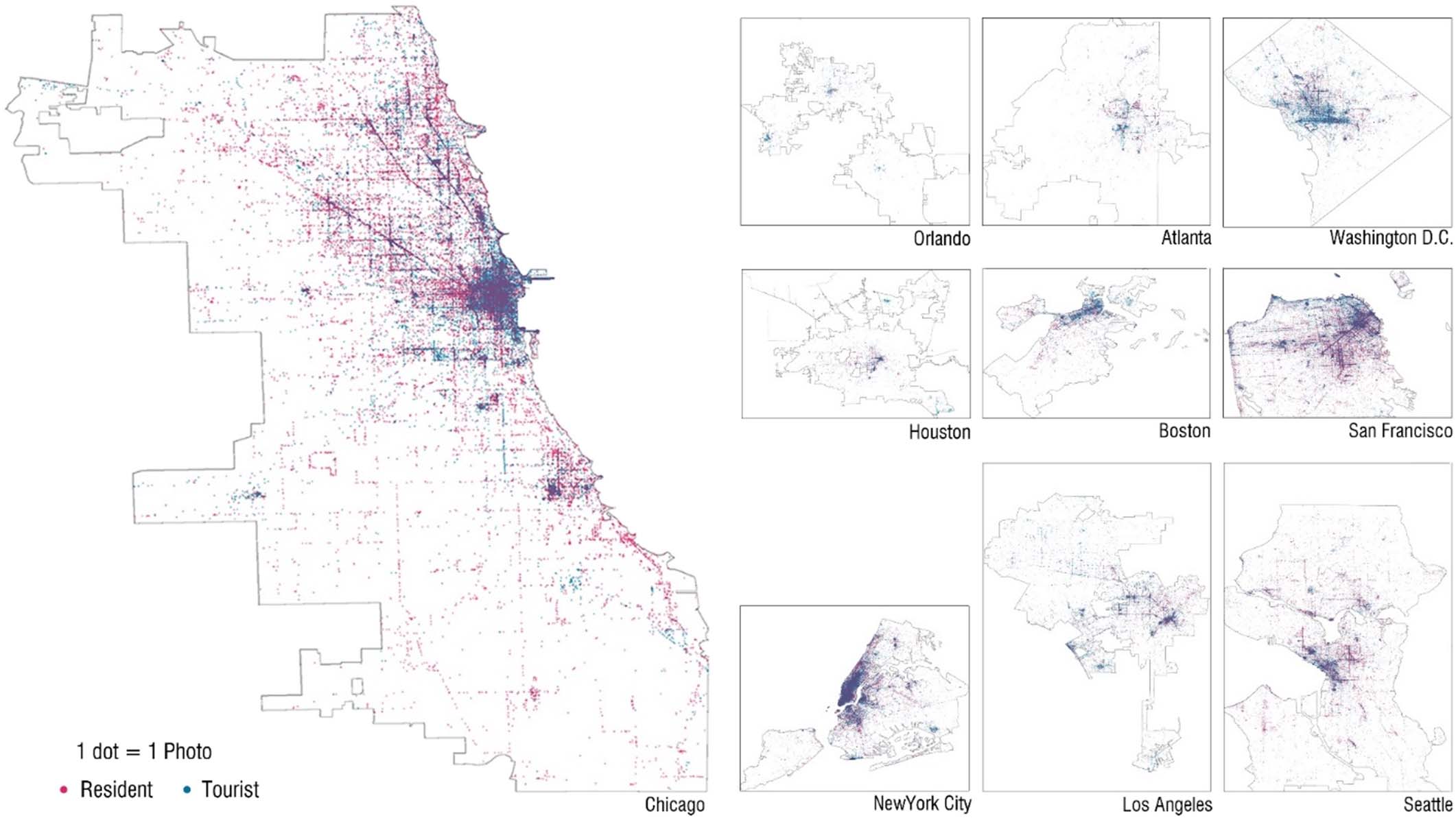
Our analysis revealed some striking patterns. For starters, tourists and locals often visit different parts of the city. In cities like Atlanta and Washington, D.C., the two groups were highly segregated, with tourists flocking to iconic landmarks and locals sticking to neighborhoods and parks. On the other hand, cities like New York City and Chicago showed a much higher level of mixing, with both groups sharing spaces like downtown areas and cultural hubs.
We also found that tourists tend to cluster around famous landmarks, museums, and high-end hotels, while locals prefer parks, libraries, and culturally rich neighborhoods. For example, in Chicago, tourists were drawn to Navy Pier and Millennium Park, while locals frequented areas like Logan Square and Humboldt Park.
💡 Why This Matters: Building Better Cities for Everyone
So, what does this mean for cities and urban planners? Understanding where tourists and locals go—and where they don’t—can help cities design spaces that cater to both groups. For example, areas with high tourist traffic might need better infrastructure to handle crowds, while neighborhoods with mostly local visitors could benefit from more community-focused amenities.
Our findings also highlight the importance of creating multifunctional spaces that appeal to both tourists and locals. Think of places like Central Park in New York City or Millennium Park in Chicago—these spaces are beloved by both groups because they offer something for everyone. By identifying areas with low tourist-local interaction, cities can work to bridge the gap and create more inclusive urban environments.
Looking ahead, we’re excited to expand this research to more cities and explore how factors like transportation, economic dependence on tourism, and cultural events influence these patterns. By combining big data with urban planning, we can help cities thrive as vibrant, shared spaces for all.
Curious to see how your city stacks up? Check out our interactive maps and tag clouds to explore the data for yourself!