
Detecting Tourism Destinations via Geospatial Analysis
🔍 Unlocking the Secrets of Tourist Hotspots with Big Data
Have you ever wondered how tourists decide where to go when visiting a new city? Or how cities can better understand which attractions are most popular? In our latest research, we tackled these questions head-on by analyzing millions of geo-tagged photos from Flickr. By leveraging the power of cloud computing and advanced geospatial analysis, we developed a system that can automatically detect and rank tourist destinations in major cities. This isn’t just about cool tech—it’s about helping cities manage tourism better and giving travelers insights into where to go next.
🛠️ How We Did It: Mining Millions of Photos
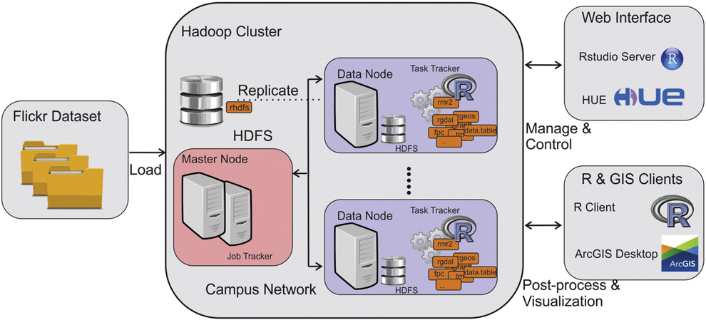
Our research started with a massive dataset: over 49 million geo-tagged photos from Flickr, spanning cities across the globe. Each photo came with valuable metadata, including geographic coordinates, timestamps, and user-generated tags (like “Eiffel Tower” or “Golden Gate Bridge”). But how do you make sense of such a huge amount of data? That’s where RHadoop, a powerful combination of R and Hadoop, came in. We used this platform to process and analyze the data efficiently, breaking it down into manageable chunks.
Here’s a simplified breakdown of our process:
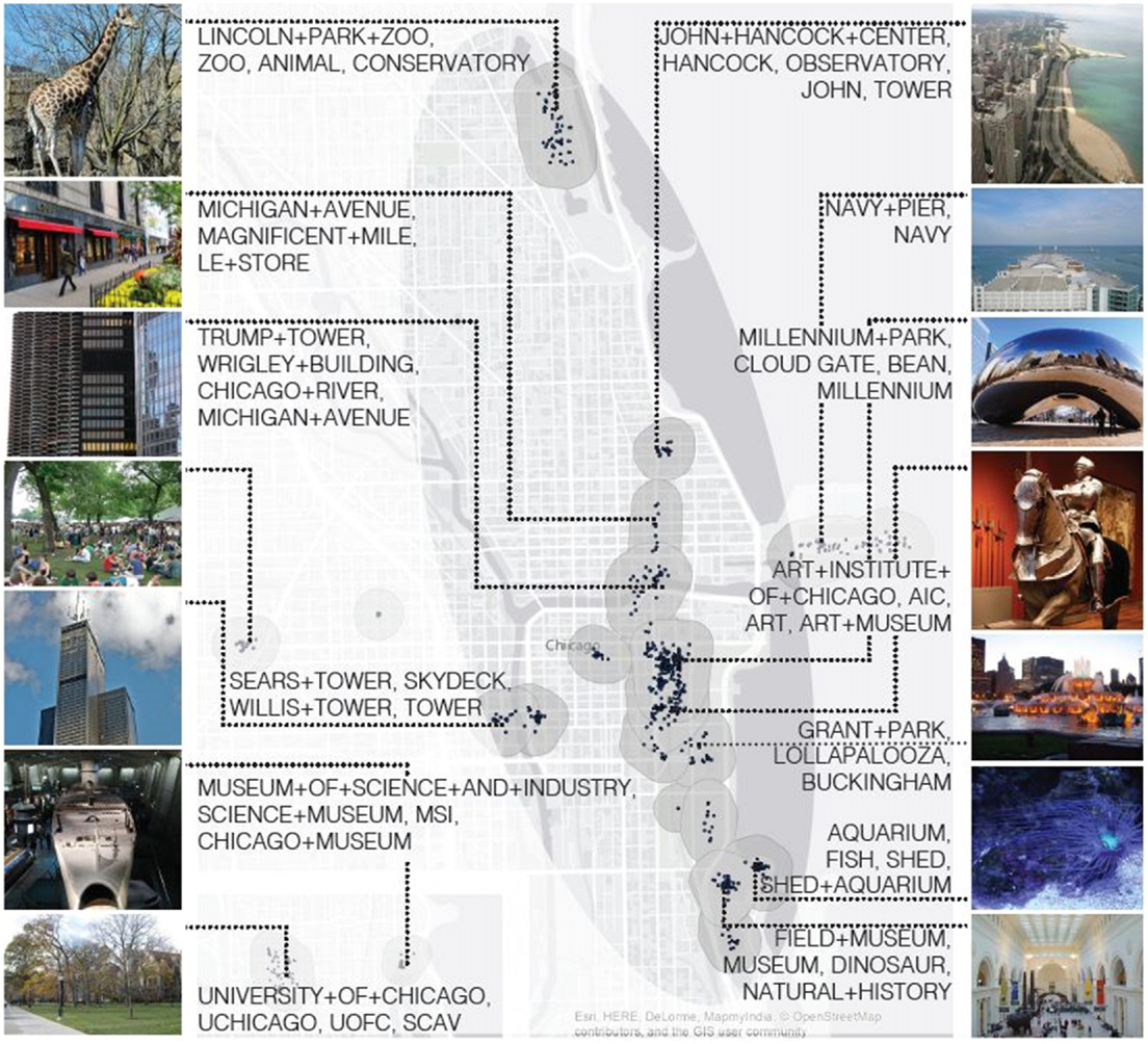
- Data Collection: We focused on photos taken within specific city boundaries, extending those boundaries to include nearby attractions (like Disney World near Orlando).
- Tag Analysis: We analyzed the tags associated with each photo, calculating features like how often a tag appeared, how many users used it, and its geographic spread.
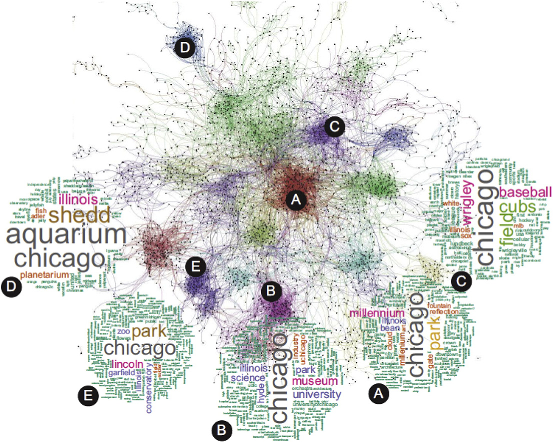
- Clustering: Using advanced algorithms like DBSCAN, we grouped photos with similar tags and locations to identify tourist hotspots.
- Ranking: Finally, we ranked these hotspots based on their popularity and compared our results with rankings from travel websites like PlanetWare.
📊 What We Found: Tourist Hotspots Revealed
Our system successfully identified and ranked popular tourist destinations in cities like Chicago, New York, and San Francisco. For example, in Chicago, we detected clusters around well-known attractions like Millennium Park and Navy Pier. The tags associated with these clusters—like “Cloud Gate” and “Bean”—clearly reflected the landmarks tourists were visiting.
We also found that our rankings closely matched those from professional travel guides. For instance, in Boston, our top-ranked spots included Boston Common and the Public Garden, which are consistently highlighted by travel websites. This validation gave us confidence that our system could provide accurate and useful insights for both tourists and city planners.
💡 Why This Matters: The Future of Tourism Research
Our research isn’t just about identifying tourist hotspots—it’s about paving the way for smarter tourism management. By understanding where tourists go and what they’re interested in, cities can improve infrastructure, marketing, and even crowd control. For example, if a city knows that a particular attraction is consistently overcrowded, it can take steps to manage visitor flow or promote lesser-known alternatives.
Looking ahead, we see exciting possibilities for expanding this work. For instance, we could incorporate data from other platforms like Instagram or Twitter to get an even richer picture of tourist behavior. We could also use real-time data to provide up-to-the-minute recommendations for travelers. The potential applications are endless, and we’re just scratching the surface.
So, the next time you’re planning a trip, remember: behind every great travel recommendation, there’s a team of researchers crunching the numbers to make your adventure unforgettable. 🌍✨