Tracking Human Activity Through Smartphones
🔍 How Your Smartphone Can Unlock the Secrets of Human Activity
Have you ever wondered how your daily movements—whether it’s a walk in the park, a trip to the grocery store, or a commute to work—shape your health and behavior? We did too! That’s why we set out to explore how smartphones, devices most of us carry every day, can help us understand the intricate relationship between human activity and the environment. 🌍
In our latest research, we developed a system that uses your smartphone to track your steps, location, and even the time you spend in different places. By combining this data with open-source maps, we can paint a detailed picture of how people interact with their surroundings. The implications? This could revolutionize how we study public health, urban planning, and even dietary habits. Let’s dive into how we did it and what we discovered!
🛠️ How We Turned Smartphones into Activity Trackers
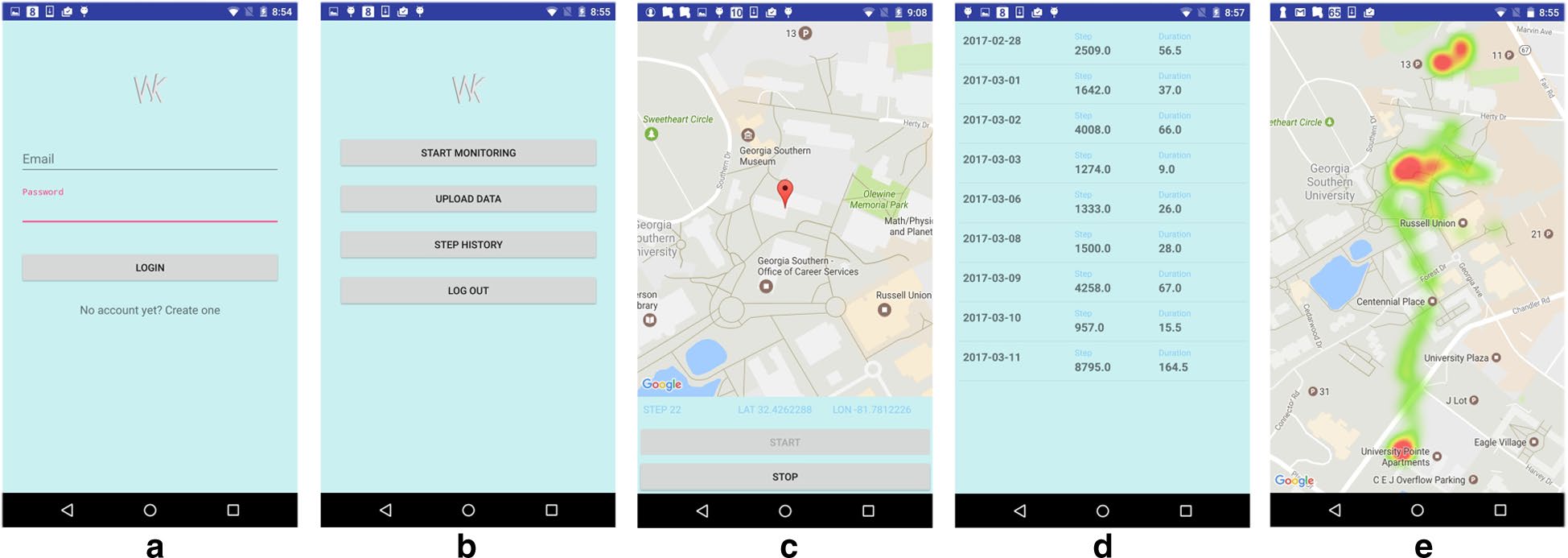
We built an app that runs quietly in the background of your smartphone, using its built-in GPS and motion sensors to track your movements. But here’s the cool part: instead of just counting your steps, we linked those steps to specific locations. This means we can tell not just how much you’re moving, but where you’re moving.
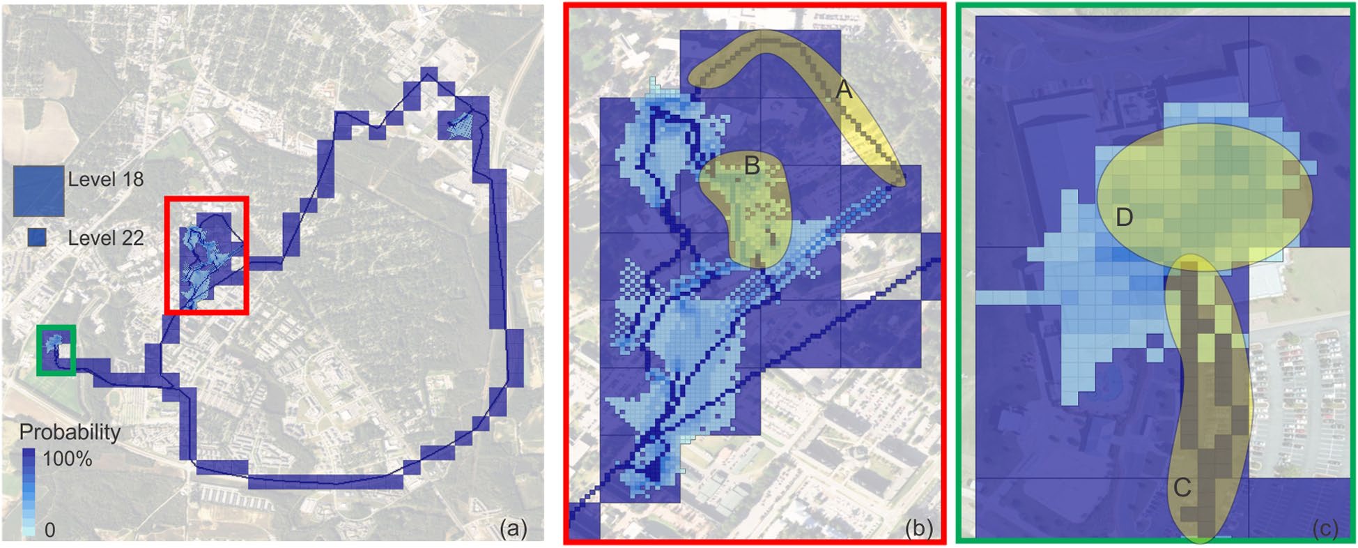
To make this work, we used a clever technique called sequential tile scanning, which breaks down your activity into small, manageable chunks (or “tiles”) on a map. These tiles are part of a system used by OpenStreetMap (OSM), a free, crowd-sourced map of the world. By using OSM’s tile system, we could analyze your activity at different scales—from a single street corner to an entire neighborhood.
We also tackled a big challenge: battery life. GPS can drain your phone’s battery quickly, so we designed the app to switch between GPS and other location services (like Wi-Fi or cell towers) depending on your activity. This way, we could track your movements without leaving you with a dead phone by lunchtime.
📊 What We Found: Your Activity, Mapped in 3D
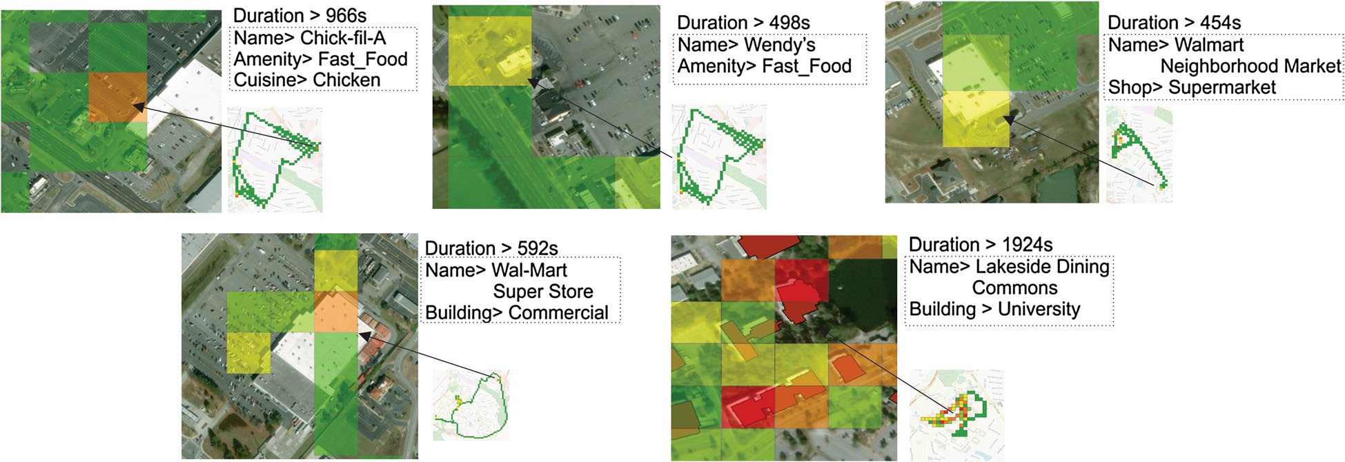
When we tested the app, we discovered some fascinating insights. For example, we could clearly see where people were most active—like recreational centers or sports facilities. We also mapped how long people spent in different places, which helped us identify “anchor points” like homes and workplaces.
One of the most exciting parts of our research was creating probability surfaces. These surfaces show how accurate our location data is. For instance, if you’re walking outside, GPS gives us a precise location. But if you’re indoors, the accuracy drops. By using probability surfaces, we could still estimate your likely path, even when the data wasn’t perfect.
💡 Why This Matters: From Health to Urban Planning
So, what does all this mean for the real world? For starters, this system could help public health researchers understand how the environment influences physical activity. For example, if we know people walk more in areas with parks or bike paths, cities can invest in those features to promote healthier lifestyles.
It could also revolutionize how we study dietary habits. By linking activity data with points of interest (like restaurants or grocery stores), we can see where people are eating and how that affects their health. Imagine being able to identify “food deserts”—areas with limited access to healthy food—and taking steps to address them.
Looking ahead, we’re excited to expand this research. We want to test the system with larger groups of people and explore how it can be used in different fields, from transportation planning to disaster response. The possibilities are endless!
So next time you take a walk or grab a coffee, remember: your smartphone might just be helping us unlock the secrets of human activity. And who knows? One day, this research could help create healthier, more livable cities for everyone. 🌟